Brief Description
The topic of navigation and the Vikings are introduced by questions and a short story. With the construction of an Indian Circle, the students reproduce the technique the Vikings probably have used to determine the cardinal directions from the Sun’s apparent path during the day to stay on course to Iceland and Greenland on the open sea. In addition, this will demonstrate that the common time is only loosely connected to the rotation of the Earth and the apparent path of the Sun in the sky.
This resource is part of the educational kit "Navigation Through the Ages". You can read more about the kit in the presentation attached. Find all related resources selecting the category "Navigation Through the Ages" and "secondary level". This resource is under peer-review, proof reading, and will be updated and improved in the coming year.
Goals
With this activity, the students will learn that
- the Vikings were skilled sailors and used to navigate by the Sun.
- the cardinal directions can be determined by the position of the Sun.
- the astronomical (local) noon does not coincide with noon on the clock.
Learning Objectives
At age 14, students should already understand the concepts of latitude and longitude for defining a position on Earth. This knowledge is combined with basic astronomy. In particular, they will learn
- aspects on ancient navigational skills and tools.
- historical facts from during the Viking age and some connections to European history in general.
- something about who the Vikings were and where they lived.
- how the position of the Sun in the sky is connected to cardinal directions on Earth.
- how the Vikings supposedly used a sun compass to navigate through the Atlantic.
- how to build a simple sun compass using the principle of the Indian Circle.
- why the common time we use is detached from the astronomical time frame.
Evaluation
The evaluation is done twofold: by checking the results of the activities and from the answers of the students and their discussions.
The activity section is flanked by questions that are answered in order of their appearance as follows:
Introduction
Ask the students, if they had an idea for how long mankind already uses ships to cross oceans.
It is believed that ships have been used to cross large distances already 3000 BC or earlier.
Ask them, what could have been the benefit to try to explore the seas.
Finding new resources and food, trade, spirit of exploration, curiosity.
Ask the students, how they find the way to school every day. What supports their orientation to not get lost?
Known landmarks like roads, prominent buildings, traffic lights, bus stops, i.e. reference points.
Ask the students, how navigators were able to find their way on the seas.
Compass (rather late invention), sailing along the coastline and lighthouses (landmarks), celestial objects (Sun, Moon, stars)
Story
Q: Have you heard from the Vikings before?.
A: Sure they have. The students probably mention stereotype ideas about their appearance (horned helmet) and their brutality.
Q: Where did they live originally?.
A: Norway, Sweden, Denmark
Q: What were the typical jobs of the Vikings?.
A: Farmers, explorers and traders, but also warriors.
Q: The Vikings settled on the Shetland and Faroe Islands, on Iceland, and on Greenland. How far are these destinations from the Norwegian coast? How did they get there?.
A: (Could be checked e.g. with Google Earth)
Greenland: 1370 nautical miles or 2540 km
Iceland: 670 nautical miles or 1240 km
Q: What knowledge and skills did the Vikings use to navigate? How did they know that they were on course?.
A: Migration routes of animals (birds, whales), smells and sounds; coastlines; celestial navigation: stars and sun; elevation corresponds to length of shadow of a gnomon and latitude; sun compass
Q: How did they know that they were on the correct latitude of the destination?.
A: see above (sun compass, shadow board, stars)
Activity: The Sun leads the way
The success of the activity can be checked with a magnetic compass or GPS based applications.
Closure
Q: Why does the shortest shadow during the day point north?.
A: The shadow is shortest, when the Sun is highest during the day. In the northern hemisphere, this is when the Sun transits the meridian, i.e. it is exactly south. The shadow hast to point north.
Q: What time was it, when the Sun was in the south?.
A: Most probably not 12 h, noon.
Q: Why does the clock show something else than 12 h at local noon?.
A: Time zones, daylight saving time, equation of time (bonus knowledge)
Q: The length of the shadow at local noon changes throughout the year. Why?.
A: The declination of the Sun changes. This is because the Earth with its titled axis revolves around the Sun. From the surface of the Earth, the Sun appears to be alternating between the Tropic of Cancer and the Tropic of Capricorn. This modifies the elevation of the Sun seen from any point on Earth.
Q: Imagine you repeat the experiment at different latitudes. At any given day during the year, would the shadow at local noon be shorter or longer at higher latitudes? Explain why.
A: The shadow is longer at higher latitudes, because the Sun is lower.
Materials
The list contains items needed by one student. Some of them can be shared by two to four individuals.
- Worksheet
- A stick or a rod as gnomon (25 cm high, 1 cm thick)
- Anything to put marks and draw lines on the ground (depends on surface, e.g. chalk, stick, stones, marbles)
- Rope or cord (depends on size)
- Pencil
- Clock
Background Information
Latitude and longitude

Figure 1: Illustration of how the latitudes and longitudes of the Earth are defined (Credits: Peter Mercator, djexplo, CC0).
Any location on an area is defined by two coordinates. The surface of a sphere is a curved area, but using coordinates like up and down does not make much sense, because the surface of a sphere has neither a beginning nor an ending. Instead, we can use spherical polar coordinates originating from the centre of the sphere, where the radius is fixed by its size (Figure 1). Two angular coordinates remain which for the Earth are called the latitude and the longitude with the rotation providing the symmetry axis. The North Pole is defined as the point, where the theoretical axis of rotation coincides with the surface of the sphere and the rotation is counter-clockwise when looking at the pole from above. The opposite point is the South Pole. The equator is defined as the great circle half way between the two poles. The latitudes are circles parallel to the equator. They are counted from 0° at the equator to ±90° at the poles. The longitudes are great circles connecting the two poles of the Earth. For a given position on Earth, the longitude going through the zenith, the point directly above, is called the meridian. This is the line the Sun apparently crosses at local noon. The origin of this coordinate is defined as the meridian of Greenwich, where the Royal Observatory of England is located. From there, longitudes are counted from 0° to ±180°.
Example: Heidelberg in Germany is located at 49.4° North and 8.7° East.
Elevation of the pole (pole height)
If we project the terrestrial coordinate system of latitudes and longitudes at the sky, we get the celestial equatorial coordinate system. The earth equator becomes the celestial equator and the geographical poles are extrapolated to build the celestial poles. If we were to make a photograph with a long exposure of the northern sky, we would see from the trails of the stars that they all revolve about a common point, i.e. the northern celestial pole (Figure 2).

Figure 2: Trails of stars at the sky after an exposure time of approximately 2 hours (Credit: Ralph Arvesen, Live Oak star trails, https://www.flickr.com/photos/rarvesen/9494908143, https://creativecommons.org/licenses/by/2.0/legalcode).
In the northern hemisphere, there is a moderately bright star near the celestial pole, the North Star or Polaris. If we stood exactly at the geographical North Pole, Polaris would always be directly overhead. We can say that its elevation would be (almost) 90°. This information already introduces the horizontal coordinate system (Figure 3). It is the natural reference we use every day. We, the observers, are the origin of that coordinate system located on a flat plane, whose edge is the horizon. The sky is imagined as a hemisphere above. The angle between an object in the sky and the horizon is the altitude or elevation. The direction within the plane is given as an angle between 0° and 360°, the azimuth, which is usually measured clockwise from North. In navigation, this is also called the bearing. The meridian is the line that connects North and South at the horizon and passes the zenith.

Figure 3: Illustration of the horizontal coordinate system. The observer is the origin of the coordinates assigned as azimuth and altitude or elevation (Credit: TWCarlson, https://commons.wikimedia.org/wiki/File:Azimuth-Altitude_schematic.svg, „Azimuth-Altitude schematic“, https://creativecommons.org/licenses/by-sa/3.0/legalcode).
For any other position on Earth, the celestial pole would appear at an elevation smaller than 90°. At the equator, it would just appear at the horizon, i.e. at an elevation of 0°. The correlation between the latitude (North Pole = 90°, Equator = 0°) and celestial poles is no coincidence. Figure 4 combines all three mentioned coordinate systems. For a given observer at any latitude on Earth, the local horizontal coordinate system touches the terrestrial spherical polar coordinate system at a single tangent point. The sketch demonstrates that the elevation of the celestial north pole, also called the pole height, is exactly the northern latitude of the observer on Earth.

Figure 4: When combining the three coordinate systems (terrestrial spherical, celestial equatorial, local horizontal), it becomes clear that the latitude of the observer is exactly the elevation of the celestial pole, also known as the pole height (Credit: M. Nielbock, own work).
Early navigational skills
Early seafaring peoples often navigated along coastlines before sophisticated navigational skills were developed and tools were invented. Sailing directions helped to identify coastal landmarks (Hertel, 1990). To some extent, their knowledge about winds and currents helped them to cross short distances, like e.g. in the Mediterranean.
Soon, the navigators realised that celestial objects, especially stars, can be used to keep the course of a ship. Such skills have been mentioned in early literature like Homer’s Odyssey which is believed to date back to the 8th century BC. There are accounts of the ancient people of the Phoenicians who were able to even leave the Mediterranean and ventured on voyages to the British coast and even several hundred miles south along the African coast (Johnson & Nurminen, 2009). A very notable and well documented long distance voyage has been passed on by ancient authors and scholars like Strabo, Pliny and Diodorus of Sicily. It is the voyage of Pytheas, a Greek astronomer, geographer and explorer from Marseille who around 300 BC apparently left the Mediterranean by passing Gibraltar and made it up north until the British Isles and beyond the Arctic Circle, where he possibly reached Iceland or the Faroe Islands that he called Thule (Baker & Baker, 1997). Pytheas already used a gnomon or a sundial, which allowed him to determine his latitude and measure the time during his voyage (Nansen, 1911).
Sailing along a latitude
At these times, the technique of sailing along a parallel (of the equator) or latitude was used by observing circumpolar stars. The concept of latitudes in the sense of angular distances from the equator was probably not known. However, it was soon realised that when looking at the night sky, some stars within a certain radius around the celestial poles never set; they are circumpolar. When sailing north or south, sailors observe that the celestial pole changes, too, and with it the circumpolar radius. Therefore, whenever navigators see the same star culminating – transiting the meridian – at the same elevation, they stay on the “latitude”. For them, it was sufficient to realise the connection between the elevation of stars and their course. Navigators had navigational documents that listed seaports together with the elevation of known stars. To reach the port, they simply sailed north or south until they reached the corresponding latitude and then continued west or east.
Nowadays, the easiest way to determine one’s own latitude on Earth is to measure the elevation of the North Star, Polaris, as a proxy for the true celestial North Pole. In our era, Polaris is less than a degree off. However, 1000 years ago, it was 8° away from the celestial pole.
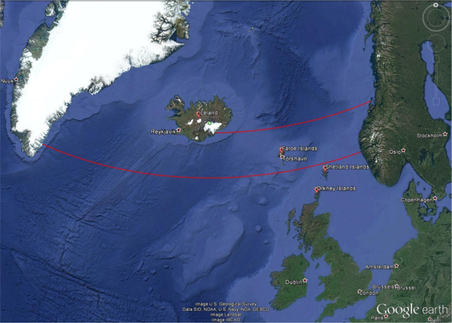
Figure 5: Vikings probably used the technique of sailing along latitude to reach destinations west of Scandinavia (red lines). Iceland is on the 64th northern latitude and 680 nautical miles away from Norway’s coast. The voyage to Greenland along the 61st northern latitude passes the Shetland and Faroe Islands. A stopover in Iceland is a viable alternative.
However, using Polaris to determine the north bearing and one’s own latitude of course only works when it is dark enough to see the 2 mag bright star. At a clear day, this is only possible during Nautical or Astronomical Twilight, i.e. when the Sun has set and its centre is more than 6° below the horizon. However, at latitudes higher than 61° North, the Sun can stay above such low (negative) elevations, especially around summer solstice. This is the realm north of the Shetland Islands, i.e. certainly the Faroe Islands and Iceland. Hence, observing Polaris becomes rather difficult during summer, which is the preferred season for sailing. For latitudes north of the Arctic Circle, where sea ice can block passages during winter, the sun never sets for a certain period during summer. Therefore, other techniques were needed for navigation.
The Vikings
The Vikings were Northern Germanic tribes who were known for their seamanship, their influential culture and a wide trade network. And they were feared for their raids and pillages that were executed with roaring brutality. However, contrary to common urban legends, the Vikings were not the filthy, savage barbarians that wore horned helmets when going into battle. Instead, they seemed to be well groomed, and bathed at least once per week (Berg Petersen, 2012). Their origins are the coastal regions around western and southern Scandinavia as well as Denmark. During their explorations, they settled in Iceland, Greenland, Normandy and the British Isles. However, they ventured as far as Northern America, all around Europe, the Black Sea and the Caspian Sea (Figure 6).

Figure 6: Map of Viking expansion between the 8th and 11th century. Their origins are the Norwegian coast, Southern Sweden as well as Denmark (Credit: Max Naylor, https://commons.wikimedia.org/wiki/File:Viking_Expansion.svg, public domain).
The beginning of the Viking Era is commonly dated to 793 with the raid of Christian monastery of Lindisfarne (Graham-Campbell, 2001) in Northumbria, England. However, the Gallo-Roman historian St. Gregory of Tours reports on an earlier attack by a Danish king named Chlochilaicus on Austrasia, the homeland of the Merovingian Franks, around 520. It is believed that this Danish king may be identical to the mythical character of Hygelac in the Beowulf poem (Susanek, 2000). The Viking Era ended with the Battle of Hastings between the English and the Norman-French, who were descendants of the Vikings, and the destruction and abandonment of Hedeby, an important Viking settlement and trading post, both in 1066. As it marked the Norman conquest of Britain, the Battle of Hastings was such an important turning point in British history that it was documented with colourful and vivid pictures on the Bayeux Tapestry (Figure 7), made in the 1070s which is still in brilliant shape (Hicks, 2007).

Figure 7: A segment of the Bayeux Tapestry depicting Odo, Bishop of Bayeux and half-brother to William the Conqueror, rallying the Norman troops during the Battle of Hastings in 1066. The Bayeux Tapestry is a 70-metre long embroidered cloth depicting the Battle of Hastings and the events leading up to the Norman Conquest of England. It was probably commissioned by Odo himself (Hicks, 2007) (https://commons.wikimedia.org/wiki/File:Odo_bayeux_tapestry.png, public domain).
Viking navigation
The Vikings were famous for their longships, multi-purpose ships that could be used on rivers, shallow coastal waters and oceans. They were used for trade, exploration and warfare. Depending on the size, they could carry from a dozen up to 80 sailors. Because of their shallow draught, many of them did not need a harbour to make landfall but could simply be beached. Those ships were usually decorated with carved ornaments. Propulsion was provided by sail or oars which could lead to speeds of 15 to 20 knots.

Figure 8: The "Viking", a replica of the Gokstad Viking ship, at the Chicago World Fair 1893 (Di Cola & Stone, 2012). With a crew of 11, it crossed the Atlantic and reached Chicago within 2 months (public domain).
Assuming an average speed of 5 knots, crossing the Northern Sea would have been possible within one or two days. Longer trips, e.g. from Norway to Iceland would have been achieved within five to seven days.
The Viking sailors were very experienced in interpreting the signs nature provides. They were able to read the migratory routes of birds (Forte, Oram, & Pedersen, 2005) and whales as well as the smell and sound that the wind carries from distant shores. The Vikings probably did not have any sea charts, but they used chants and rhymes that contained sailing information as mentioned in the medieval Hauksbók chronicle (Sawyer, 1997) and were passed on from generation to generation. For instance, the route from southern Norway to Greenland passes the Shetland Islands and Iceland. Their sightings could be used to correct the course, which perfectly coincides with staying on latitude 61° North. Therefore, the Vikings must have had skills to follow it.

Figure 9: Illumination of the northern and southern hemisphere of the Earth during its orbit around the Sun (Credit: Tau'olunga, https://en.wikipedia.org/wiki/File:North_season.jpg, CC 0).
As mentioned before, the Sun played an important role for finding a ship’s course. The difficulty with the Sun compared to the stars is that the Sun changes its declination, i.e. the elevation above the equator. The reason is that the Earth with its tilted axis revolves around the Sun. In the northern summer, the northern hemisphere faces the Sun, while during northern winter, it is the southern hemisphere. The range, under which the Sun appears in the zenith, is the latitudes between 23.4° north, the Tropic of Cancer, and 23.4° South, the Tropic of Capricorn. For any given location on Earth, the Sun’s elevation while it transits the meridian – the line that connects North and South at the horizon through the zenith – changes by the same amount.

Figure 10: At summer solstice, the Sun is directly above the Tropic of Cancer. Its apparent position changes during the year (Credit: Przemyslaw "Blueshade" Idzkiewicz, https://commons.wikimedia.org/wiki/File:Earth-lighting-summer-solstice_EN.png, “Earth-lighting-summer-solstice EN”, https://creativecommons.org/licenses/by-sa/2.0/legalcode).
For latitude of 61° north, the elevation of the Sun above the horizon is shown in Figure 11. At noon, it changes by almost 47°. However, the rate of change is not constant throughout the year. We can assume a variation of the solar elevation of up to 1° to be acceptable for navigational purposes.

Figure 11: The diurnal and annual elevation of the Sun above the horizon for a latitude of 61° north (Credit: Created with the sun chart path program of the University of Oregon, USA, http://solardat.uoregon.edu/SunChartProgram.html).
If we allow such a variation during two consecutive days, the Sun could be used at any day of the year. This means, within two days the declination of the Sun – or its elevation at noon – never changes more than 1°. This corresponds to a deviation of 8 km after travelling for 240 sea miles. As already pointed out, two days are sufficient for voyages through the Northern Sea. For five to seven day journeys, the allowed period is between end of May and beginning of July. This is enough to travel from southern Norway to Iceland. The corresponding drift due to the changing solar elevation amounts to 25 km or less. For longer travels, e.g. to Greenland, the course can be adjusted by landmarks on the way when for instance passing the Shetland Islands, the Faroe Islands and Iceland. Is there evidence for navigational tools the Vikings used with the Sun?
The Sun Shadow Board
Sailing along latitude was probably facilitated by a device that was called solskuggerfjøl (sun shadow board, Figure 12). 18th century sailors of the Faroe Islands have been seen using a wooden disk of up to 30 cm in diameter with engraved concentric rings and a central gnomon whose height could be adjusted (Tjgaard, 2011). It was put inside a bucket with water to cancel out ship movements. However, it is quite likely that it was already used during the Viking age.
If we assume a negligible change of the sun’s declination, the shadow of the gnomon at noon can be calibrated to a latitude by aligning the tip of the shadow with a circle. When read during noon of the following days, the shadow should again touch the same circle. If the shadow is shorter, the position is too far South; if it is longer, the location is too far North.
 Figure 12: Sketch of the Viking sun shadow board (Credit: M. Nielbock, own work).
The Sun Compass
The magnetic compass was unknown in Europe during the Viking age. And it would have been quite useless for them anyway, because the magnetic field of the Earth is far from homogeneous. The phenomenon that the magnetic poles do not align well with the geographical ones is called magnetic declination. In addition, the field lines are strongly curved. And both processes change in time (Figure 13). Measuring campaigns like ESA’s SWARM satellites constantly monitor the magnetic field (European Space Agency, 2013).

Figure 13: Change of the magnetic north pole and its position relative to Scandinavia (Credit: Created with the NOAA Historical Magnetic Declination Viewer, http://maps.ngdc.noaa.gov/viewers/historical_declination/).
Thus, especially at high latitudes, a magnetic compass would have let the Vikings lose their way more often than it would have aided them in finding the correct course. But it seems they were able to find the cardinal directions using the Sun.
In 1948, fragments of a small wooden disk were found during historic excavations of an abandoned monastery of Uunartoq in southwest Greenland (Figure 14). In the following decades, people started to interpret it as a navigational tool to determine the cardinal directions using the Sun (Thirslund, 2007). However, even to date, there are doubts that it truly served that purpose. Nonetheless, there are quite remarkable scientific analyses that demonstrate that in fact this disk could have been a combination of a sundial, a compass, and a sun shadow board (Bernáth, Blahó, Egri, Barta, & Horváth, 2013).

Figure 14: Image of the original wooden disk fragment found in Uunartoq, Greenland. Annotations denote elements for its possible usage as a sun compass (Bernáth et al., 2013). When the shadow is aligned with the shadow lines, North is up. Incisions in that direction permit measuring the shadow length (Credit: Lennart Larsen, Danish National Museum, http://samlinger.natmus.dk/DO/10775, “Trædisk_Grønland”, background of photograph removed and annotations added by Markus Nielbock, https://creativecommons.org/licenses/by-sa/2.0/legalcode).
Incised lines have been identified as paths of a shadow cast by a central gnomon during the days of equinox and summer solstice at a latitude of 61° north. These lines hypothetically helped to determine local noon, i.e. when the Sun attains its highest elevation when crossing the meridian. This moment indicates the time when the device can be used. At local noon, a central gnomon produces a shadow that points north. Similar to the sun shadow board mentioned above, incisions on the wooden board towards the northern direction can be used to determine possible deviations from the course along a predefined latitude.
Indian Circle
The Indian Circle is an ancient tool to find the cardinal directions by following the shadow of a gnomon cast by the Sun (Isler, 1989). It is basically a sundial. This demonstrates that this knowledge has been around already for millennia. The principle is very simple and only needs a gnomon that casts a shadow of the Sun and is placed at the centre of a circle drawn around it (Figure 15). The path of the tip of the shadow is followed during the day. Finally, the circle drawn around the gnomon intersects the shadow path twice – once in the morning and once in the afternoon. The line connecting these two intersections follows the West-East direction. A line perpendicular to this that runs through the base of the gnomon indicates the North-South direction, i.e. it is the projection of the meridian.

Figure 15: Illustration of how the Indian Circle can help find the cardinal directions (Credit: MichaelFrey, https://commons.wikimedia.org/wiki/File:Indischer_Kreis-Schräg.svg, „Indischer Kreis-Schräg“, translated and cleaned up annotations by Markus Nielbock, https://creativecommons.org/licenses/by-sa/3.0/legalcode).
Local time and time zones
The shadow of a gnomon is shortest and points north, whenever the Sun is exactly south (northern hemisphere). This is what defines local noon. Since the Earth rotates continuously, the apparent position of the Sun changes as well. This means that at any given point in time local noon is actually defined for one longitude only. However, clocks show a different time. Among other effects, this is due to daylight saving time during summer and the time zones (Figure 16). Here, noon happens at many longitudes simultaneously. However, it is obvious that the Sun cannot transit the meridian for all those places at the same time. Therefore, the times provided by common clocks are detached from the “natural” local time a sundial shows.
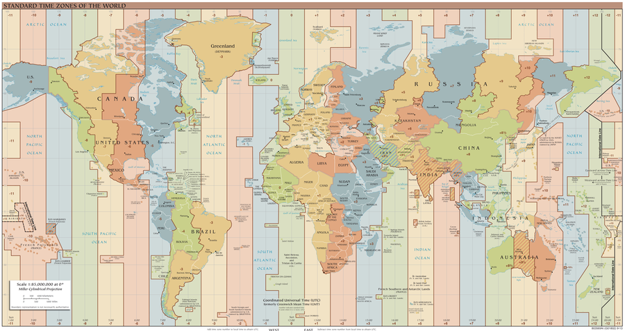
Figure 16: World time zones. Instead of the local time that is based on the apparent course of the Sun in the sky and valid for single longitudes only, the common clocks show a time based on time zones which applies to many longitudes simultaneously (Credit: TimeZonesBoy, https://commons.wikimedia.org/wiki/File:Standard_World_Time_Zones.png, https://creativecommons.org/licenses/by-sa/4.0/legalcode).
Full Activity Description
Introduction
It would be beneficial, if the activity be included into a larger context of seafaring, e.g. in geography, history, literature, etc.
Tip: This activity could be combined with other forms of acquiring knowledge like giving oral presentations in history, literature or geography highlighting navigation. This would prepare the field in a much more interactive way than what a teacher can achieve by summarising the facts.
Tip: There are certainly good documentaries available on Vikings and sea exploration that could be shown as an introduction.
https://www.youtube.com/watch?v=jvDUVFL6sqg
https://www.youtube.com/watch?v=6mkib3lYA2s
https://www.youtube.com/watch?v=uCMhlBan3Ms
Questions, Answers and Discussion
Ask the students, if they had an idea for how long mankind already uses ships to cross oceans. One may point out the spread of the Homo sapiens to islands and isolated continents like Australia. Ask them, what could have been the benefit to try to explore the seas. Perhaps, someone knows historic cultures or peoples that were famous sailors. The teacher can support this with a few examples of ancient seafaring peoples, e.g. from the Mediterranean and the art of navigation.
Ask the students, how they find the way to school every day. What supports their orientation to not get lost? As soon as reference points (buildings, traffic lights, bus stops, etc.) have been mentioned ask the students, how navigators were able to find their way on the seas. In early times, they used sailing directions in connection to landmarks that can be recognised. But for this, the ships would have to stay close to the coast. Lighthouses improved the situation. But what could be used as reference points at open sea? Probably the students will soon mention celestial objects like the Sun, the Moon and stars.
Let the students read the story attached to this lesson unit.
Questions and Answers
Q: Have you heard from the Vikings before?
Q: Where did they live originally?
Q: What were the typical jobs of the Vikings?
Q: The Vikings settled on the Shetland and Faroe Islands, on Iceland, and on Greenland. How far are these destinations from the Norwegian coast? How did they get there?
Q: What knowledge and skills did the Vikings use to navigate? How did they know that they were on course?
Q: Vikings used the technique of sailing along latitude. How did they know that they were on the correct latitude of the destination?
Figure 17: Vikings probably used the technique of sailing along latitude to reach destinations west of Scandinavia (red lines). Iceland is on the 64th northern latitude and 680 nautical miles away from Norway’s coast. The voyage to Greenland along the 61st northern latitude passes the Shetland and Faroe Islands. A stopover in Iceland is a viable alternative.
Building the Indian Circle
The list contains items needed for one sundial.
- Worksheet
- A stick or a rod as gnomon (25 cm high, 1 cm thick)
- Anything to put marks and draw lines on the ground (depends on surface, e.g. chalk, stick, stones, marbles)
- Cord (length depends on size of shadow path)
- Pencil *Clock
This activity can be done with one sundial for the entire class or with several groups, so that the individual results can be compared.
This tool can have nearly any size. However one should first test, if the object foreseen as the gnomon in fact casts a shadow that is useful for this activity. The tip of the gnomon should produce a shadow well visible throughout the better part of the day. In essence, the thickness of the gnomon (e.g. rod, stick, pole) should be in suitable relation to its height. Keep in mind that the Sun produces an umbra and a penumbra. A good rule of thumb is that the height and the thickness should have a ratio between 25 und 30. The size of the gnomon indicated above should work in most cases.
The activity should be initiated several hours before local noon, i.e. in the morning and a well after sunrise. The weather forecast should predict rather clear skies throughout the day. Together with the students, find a flat area, where the gnomon (rod, stick) can be fixed upright.
Activity: The Sun leads the way
Put up the gnomon(s) in the morning. Mark the position of the shadow of the tip of the gnomon and enter the time in the table of the worksheet. On concrete, chalk would be a good idea. On sand or soil, small stones can be used. Return regularly (every hour at least) during the day and continue to mark the shadow and record the time so that the path can be followed. This task could be distributed among different students, e.g. according to a time table. It is important that the path of the shadow is covered at least a few hours before and after local noon, i.e. when the shadow is shortest. At the end, draw a connecting line by interpolating between the markers.
Prepare a piece of cord whose length is between the shortest and longest shadow recorded during the day. Make small loops at both ends and slide one over the gnomon rod. The other loop will hold a piece of chalk or another stick. Tighten the cord and draw a circle around the gnomon.
The circle intersects the shadow path twice. Draw a straight line between them (Figure 18). This is the line that connects West and East. The directions to North and South are perpendicular to that line. North is where the shortest shadow points to, which happens at local noon.
If the time at local noon has not been recorded, let the students return the next day (if the Sun shines) to see what time their own clocks read.
Figure 18: Illustration of how the Indian Circle can help find the cardinal directions (Credit: MichaelFrey, https://commons.wikimedia.org/wiki/File:Indischer_Kreis-Schräg.svg, „Indischer Kreis-Schräg“, translated and cleaned up annotations by Markus Nielbock, https://creativecommons.org/licenses/by-sa/3.0/legalcode).
Closure
Q: Why does the shortest shadow during the day point north?
Q: What time was it, when the Sun was in the south?
Q: Why does the clock show something else than 12 h at local noon?
Q: The length of the shadow at local noon changes throughout the year. Why?
Q: Imagine you repeat the experiment at different latitudes. At any given day during the year, would the shadow at local noon be shorter or longer at higher latitudes? Explain why.
Curriculum
Space Awareness curricula topics (EU and South Africa)
Navigation through the ages, celestial navigation, instruments
Conclusion
The activity shows how the cardinal direction can be determined with the shadow of a gnomon caused by the Sun during the day. This technique that employs simple version of a sundial is called the Indian Circle, and the students learn how to use it. It represents a navigational skill that Viking during the 8th until the 11th century used to find their course to distant destinations across the open seas. A short story is included that tells the students something about what the life of a Viking may have looked like and generates interest to study this important and influential era of European history.
This resource was developed by Markus Nielbock, Haus der Astronomie, Heidelberg, Germany.

